



The launch of EOS-05 is the first step taken by India in the field of continuous Earth observation.
Earth observation satellites have now become essential tools in governance, disaster relief, agriculture, environmental protection, and national security. These satellites provide remote sensing data about the Earth’s surface, atmosphere, and oceans, helping governments monitor changes that cannot be easily detected by ground systems. India’s Earth observation mission has been well established for years, and the launch of EOS-05 on GSLV-F17 is a significant step towards enhancing its capabilities. This is particularly significant because its ability to image from geosynchronous orbit enables repeated observations of the Indian region.
The launch of EOS-05 is part of a shift in the nature of satellite remote sensing. Earth observation has traditionally been a major application of satellites operating in low Earth orbit (LEO). These satellites will provide extremely detailed images, but due to their orbit, they will only pass over a specific area at regular intervals. This is very useful for periodic coverage, but it could be even more useful in rapidly changing conditions. These systems could be complemented by a geosynchronous imaging satellite that can observe a large area over a long period of time.
This is especially important when events occur over a period of hours rather than days. Cyclones can suddenly intensify or change direction, floods can spread across a wide area, forest fires can ignite or become uncontrollable, and maritime activity can be in a state of constant flux. Continuous satellite observations can provide authorities with more dynamic information about such events. Therefore, EOS-05 should be viewed as a complementary element to LEO satellites in the Earth observation system. LEO satellites can be used to obtain detailed images, while geosynchronous satellites can provide greater stability and continuity.
This capability is crucial for a diverse and disaster-prone country like India. Natural disasters like cyclones, floods, landslides, and forest fires frequently impact the country. Early warning, rapid assessment, and continuous monitoring are essential for effective disaster management. Frequent satellite observations can help authorities assess the evolution of a disaster situation and quickly locate affected areas. Satellite images can also be helpful in mapping inundated areas during floods. In the event of a forest fire, regular monitoring can be useful in observing changes in burned areas. This monitoring can also help understand changing weather patterns during cyclones.
But imagery is only valuable if time and skill are invested in converting it into a useful product. The real challenge for India is to make satellite observations an integral part of disaster management platforms, providing administrators, disaster management agencies, and local authorities with real-time, easily accessible information. The aim is to bridge the gap between data collection and decision-making.
Another sector that will benefit from EOS-05 and India’s overall space Earth observation capabilities is agriculture. Regular monitoring of the agricultural landscape at the ground level in India is challenging and resource-intensive. Satellite observations can be helpful in assessing agricultural indicators such as vegetation, crop conditions, and land use changes. Satellite images can be used in conjunction with weather data, soil data, and ground observations to detect the development of stress in crops and changing environmental conditions.
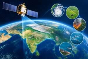
As the use of AI increases, this process can become even more efficient. Due to the sheer volume of data sent by modern satellites, manual interpretation alone is becoming increasingly difficult. AI-based systems can quickly process images, detect anomalies, and flag areas requiring immediate attention. These technologies can help accelerate crop assessment, disaster mapping, and environmental monitoring, reducing the time spent on manual analysis.
The benefits of continuous observation are also significant from an environmental perspective. India is undergoing rapid urbanization, land-use changes, increasing pressure on forests and ecosystems, and increasing stress on water resources. Satellite monitoring can be used to regularly monitor long-term vegetation changes, wetlands, water bodies, and other ecosystems. Permanent datasets can help policymakers and researchers detect trends and make more effective environmental decisions.
Satellite-based observation is also of immense strategic importance to India’s maritime interests. The country’s long coastline and location in the heart of the Indian Ocean region mean increased awareness of the marine environment is essential. Satellite monitoring can be used in conjunction with other monitoring methods to enhance knowledge about activities and changing conditions in the maritime domain.
The importance of EO is also growing from a strategic perspective. In the modern security environment, timely and reliable information has become a strategic asset. Continuous imaging can enhance situational awareness and can be used in conjunction with airborne, ground-based, and other space-based surveillance systems. Furthermore, the country needs the capability to respond to such situations. India should not rely heavily on any single satellite and should build a diverse satellite constellation that can ensure continuity of essential services even if a specific satellite is unavailable.
Therefore, building an integrated and intelligent Earth Observation (EO) ecosystem should be the key to moving forward. Data from EOS-05 should be integrated with other platforms, such as satellites, meteorology, agriculture, and disaster management. Image processing should be accelerated by implementing artificial intelligence (AI) tools and information should be made available for decision-making. The next step is for India to invest more in indigenous sensors, satellite platforms, communication systems, and data processing infrastructure.
Most importantly, India should build a complementary multi-orbit constellation of geosynchronous and long-term electric field (LEO) satellites that can provide detailed images and continuous visibility, respectively. This will provide a complete picture of the country and its neighbouring regions.
EOS-05 is not just another step forward in India’s space capabilities. It marks a paradigm shift in the approach to Earth observation, moving from periodic observations to continuous observation. However, its ultimate significance will depend on how effectively the information it generates is used in national security, environmental management, agriculture, disaster management, and governance. India’s aspiration should be to move beyond simply collecting satellite images and develop an intelligent and sustainable information system that can guide action. In this transformation, EOS-05 can prove to be an invaluable component of an informed, prepared, and technologically empowered India.


