



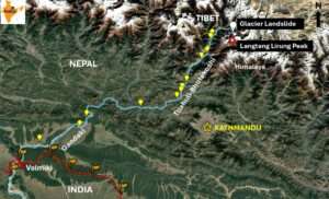
Imagine a torrent of over 100 million cubic metres of rock, ice, and mud rushing down a narrow canyon at a whopping speed of more than 170 km/h. You would have virtually no chance of outrunning it. This is what happened on 26 August 2026 in the Nepal Himalaya, 60 kilometres north of Kathmandu.
At 8:44 a.m. local time, staff at the Gyirong Port border checkpoint between Nepal and Tibet, along with hundreds of tourists travelling to Mount Kailash and a long line of trucks carrying goods, had virtually no chance to escape. A massive flood wave, more than 100 feet high and laden with rocks and sediment, surged through the area, toppling and washing away the port building and destroying the entire complex. There was no warning!
The debris flow buried several hydropower projects, washed away bridges, people, houses, and roads, leaving over 1,300 dead and 5,000 missing. The first 7 cataclysmic minutes turned into eight hours of trauma for people living along the valleys and slopes of the Bhotekoshi and Trishuli river corridors, where the debris height reached over 30 ft at some places. The current of the flow was so strong that more than 700 human remains were recovered over a distance of 150 km in the Gandaki River, also called the Narayani River downstream of Trishuli River.
All 36 gates of the Valmikinagar Gandak Barrage at the international border with India were opened to manage the sudden upstream flood from Nepal to protect downstream areas in Bihar and Uttar Pradesh. This barrage situated in West Champaran district released 1.5 lakh cusecs of water in a controlled manner. 17 bodies were reportedly recovered from the Gandak River in Uttar Pradesh and Bihar, India, more than 250 km from the source area.
Why was there no warning despite the presence of a river-level monitoring gauge? The last recorded river level at Nepal-Tibet border at the confluence of the Lhende Khola, Bhotekoshi, and Trishuli rivers was 1.62 metres at 8:40 a.m., just four minutes before the disaster struck. In the aftermath, conspiracy theories spread through the media, often accompanied by speculation from non-experts who suggested that China had played a role in precipitating the tragedy. More sober voices pointed to the role of global warming and climate change while scientists got busy with finding the cause of the floods.
What Exactly Happened? On 8 July 2025, the same Nepal–Tibet border region, including the Gyirong Port area, experienced severe flooding after a glacial lake outburst flood (GLOF) occurred upstream in the Lhende Khola basin on the Tibetan side. The flood swept away the Sino–Nepal Friendship Bridge and killed nine people. Consequently, when another devastating flood reached this year on 26 August 2026, many initially assumed that a glacial lake somewhere upstream in the central Himalaya had breached.
The confusion was compounded by an initial U.S. Geological Survey (USGS) report identifying a magnitude 4.4 earthquake at 8:37 a.m. in the region. After analysing data from nearby seismic stations, long-period seismic waves, and satellite imagery, the USGS revised its interpretation: no earthquake had occurred. Instead, the seismic signal had been generated by a landslide whose energy was equivalent to that of a magnitude-5.2 event.
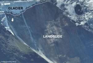
The Trigger: Further analysis of satellite imagery revealed a massive slope failure involving bedrock and overlying glacier ice on the northern side of Langtang Lirung peak in the Nepal Himalaya. The collapse occurred at an altitude of approximately 5,200 metres above sea level and plunged roughly 1,200 metres into the valley below. It mobilised an enormous volume of rock, ice, sediment, and debris, with varying estimates of over 100 million cubic metres.
The event was extraordinary in its scale, speed, and mechanism. The impact was powerful enough to generate seismic waves that were recorded globally and initially mistaken for an earthquake. The disaster was therefore not a conventional GLOF, but a cascading event involving a glacier–rock collapse, an ice–rock avalanche, and flash melting of ice into liquid water, finally turning into a supermobile debris flow. This super-mobile debris flow through the narrow canyons was restricted by steep valley slopes from spreading laterally and increasing the height of the flood wave to hundreds of feet that washed away infrastructure and settlements on its way.
Why Was There No Warning? The absence of warning at the Gyirong Port checkpoint can be explained partly by the speed and nature of the event. The collapse occurred suddenly in a remote, high-altitude area, leaving little time for detection and communication. As the mass plunged into the valley, friction and intense flash melting of ice into liquid water, and entrainment of additional water and sediment in the valley, led to a super-mobile debris flow. The resulting flow became exceptionally high-speed, travelling 22 kilometres to the checkpoint in 7 minutes, an average speed of more than 170 km/h, allowing no time for warning.
Predicting the exact timing of a sudden landslide or ice–rock avalanche remains extremely difficult in any mountainous region. Unlike a slowly rising river, such a collapse may provide no measurable upstream warning before the destructive flow is already underway. However, this does not mean that preparedness is impossible: hazard mapping, remote sensing, automatic detection systems, downstream sirens, and clearly defined evacuation plans can still reduce risk.
A Himalayan Challenge: The Himalaya contains thousands of glacial lakes of different sizes, many of which may become unstable under particular geological, climatic, or hydrological conditions. Recent mountain-related disasters include Kedarnath in 2013, Ladakh in 2014, Chamoli in 2021, and Sikkim in 2023. Each event, however, had its own trigger and sequence of processes.
It is therefore essential to distinguish a genuine glacial lake outburst flood from an ice–rock avalanche, a landslide, or a temporary river blockage followed by a sudden outburst. Understanding these interconnected hazards and preparing for the cascading disasters they can produce is truly a Himalayan task.


unfortunately, true….. a Himalayan task indeed. However, 2 things can be done. minimize structures in valleys which are vulnerable to glof. and respect nature, work on mitigation of global warming. the Data centres energy and water demands are putting inexorable pressure on natural resources. unsustainable I think
Excellent analysis 👍
Science and scientific explanations are always fascinating. Dr. Chadha has described the tragedy with great clarity. As a lower riparian country, Bharat is bound to face the consequences at some point in the near future, owing to the so called development actions of China, then through those of Nepal, if Nature allows it to exist in future.
Nature keeps sending warning signals. Humankind should observe and respect them. Jai Bharat.
As always, Dr. Chadda delves into the depth of the matter to bring clarity in complex matters. Your analysis was extremely clear, making the catastrophic complex event understandable in simple language. Kudos Dr Chadda Saab
Excellent analysis Dr. Chadha.
There are hundreds of glacial lakes all over the Himalayan mountains which have become potentially dangerous for future, largely due to global warming and temperature rise. It’s unfortunate that there’s hardly any monitoring of changes in these glacial lakes which could help in hazard assessment or possible early warning. Also many of these events have turned out to be complex cascade events involving rockfall / landslide followed by debris flow and flooding. Even the 2021 Chamoli event that claimed over 100 lives was a similar cascade event starting as a rockfall in Rontigadh area leading to flooding of the Rishi Ganga and Dhauli Ganga rivers. We demonstrated in our papers published in Science (April and October 2021) that having a dense real time seismic network around the vulnerable area can help detect the initial rockfall quite distinctly and the following cascade events. Using AI based early warning system in real time it’s possible in principle , to alert people several minutes in advance. Although the task in not straightforward, since each event can be very different from another, and issues of seismic sensor distance and adequate signal to noise ratio plague the success rate, the technology still needs to be looked at seriously. I think seismic monitoring plus river water level monitoring in real time backed by long time satellite monitoring should provide a viable system for future.
Thanks to Dr. RK Chadhs for the compilation of the tragic Nepal flash floods and landslides, triggered by a glacier collapse in late August, which has killed some 1,400 people in Nepal and Tibet.
As reported earlier, it was like an ‘apocalypse’, which caused unbelievable sorrow, grief and deep emotional pain. It’s learnt that theThe debris left behind by these floods is reported to be upto eight metres deep! The disaster has destroyed huge infrastructure too including 12 hydropower plants and buried or swept away homes, roads and many bridges.
Thus, there has been a collosal loss of life and property and one wonders if normal life would ever return to this region!
It’s learnt that the early-warning system for this catastrophe was absent or did not work.
We know arrangements for disaster warning and mitigation remain fragmented by national borders (viz. Nepal, Tibet, India), with political and security concerns and the
disaster-management operations are largely organised along national lines, even though a high-altitude collapse can have consequences beyond the country where it begins. Thus, it’s time to have an effective international disaster management system in place.
nice article sir, Thank you
Excellent reporting on the recent disaster in Nepal. Very knowledgeable. Unpredictable nature. S&T cannot stop nature. Kudos to the author.
This article is very well written, and I fully agree with its message. Geohazards of this kind can only be tackled effectively through a multinational, multi-institutional and multidisciplinary approach to early warning. The Himalayas are truly a departmental store of geohazards, yet they are also the birthplace of our river systems and a major influence on our country’s weather patterns. My compliments to the Dr. Chadha for explaining this so well.
RK is there a way to streamline the water collected up in the mountains ( am i asking for the impossible) and most important stop fiddling with nature . one can’t fight nature’s fury. thanks for your indepth analysis.
A good article. As always Dr. Chadha does it again with his excellent style and easy understanding language.
Understanding and analysing the complexity of such a Cataclysmic event is a Himalayan task. Dr. Chadha did it in excellent manner and presented his analysis & suggestions lucidly in this article.
Chaddha Sirji article well written & good reporting on the tragic incidents with great 👍 clarity