



China has long believed in the power of nomenclature. Rename a place, repeat the invented name often enough, publish it in official documents and maps—and perhaps, over time, fiction can be made to resemble fact. Beijing has tried precisely this game with Arunachal Pradesh.
India has now delivered an appropriate counter-punch—not with a military manoeuvre, but with something equally important in a territorial dispute: an unambiguous cartographic and administrative assertion of sovereignty.
The Survey of India’s official mapping of 27 locations in Arunachal Pradesh, including strategically significant villages, mountain passes, memorials and geographical landmarks, sends a simple message to Beijing: you cannot redraw Bharat’s geography by changing names on Chinese maps.
China has repeatedly attempted to give Chinese names to places in Arunachal Pradesh, which it calls “Zangnan” or South Tibet. The Chinese Civil Affairs Ministry issued its first list of six “standardised” names in 2017, followed by 15 names in 2021 and another 11 in 2023. New Delhi has consistently rejected these exercises as fictitious, vain and preposterous, making it clear that nomenclature cannot alter the undeniable reality that Arunachal Pradesh was, is and will remain an integral part of India.
The latest Indian exercise is significant because these are not merely dots on a map. The 27 locations carry history, geography and strategic relevance.
Long Ju, along the Line of Actual Control, was the site of an early India-China confrontation in 1959. Thag La, another strategically important high-altitude pass, witnessed one of the opening battles of the 1962 war. Jairampur, meanwhile, remains an important logistics hub and gateway towards the eastern frontier and the Myanmar border.
The map also identifies locations such as Maja, Bisa, Dzo La, Riza La and Pukur La, besides Sambho Sarovar, Bara Kundun and Chhota Kundun. Jaswant Garh, associated with the legendary sacrifice of Indian soldier Jaswant Singh Rawat during the 1962 war, is another important inclusion. The Sher-e-Thapa Memorial, dedicated to 1962 war hero Trilok Singh Thapa, reinforces the historical dimension of the exercise.
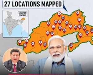
There are also villages and settlements—Sagar, Padma, Jyotinagar, Baisakhi, Dhan Bari, Pritnagar, Teritnagar, Ramnagar, Chhota Ropuk, Bara Ropuk, Shivaji Nagar, Sunpura, Kamlang Nagar and Buddhamandir—whose formal identification strengthens the consistency of India’s geographical and administrative record.
That matters. Sovereignty is not asserted only at the border fence or through the deployment of soldiers. It is also reflected in official records, maps, administration, infrastructure, elections, public services and the everyday presence of the state.
China’s strategy of renaming places is part of a broader attempt to create a narrative that supports its territorial claims. Bharat cannot afford to be passive in the face of such cartographic aggression. Beijing’s maps may carry Chinese labels, but they do not confer Chinese sovereignty.
Bharat’s response, therefore, is neither theatrical nor needlessly provocative. It is firm, factual and institutional.
And that is precisely how it should be.
There is also a larger lesson for Beijing. If China expects its territorial claims to be taken seriously, it cannot simultaneously seek to settle disputes through unilateral cartographic fiction. Renaming Indian territory does nothing to change the ground situation; instead, it risks complicating efforts to stabilise and normalise bilateral relations.
For years, Beijing has tried to make the map speak its language. New Delhi is now making Bharat’s official map speak unmistakably for Bharat.
Names can be invented. History cannot. Maps can be manipulated. Sovereignty cannot.
The message from Bharat is therefore loud and clear: Arunachal Pradesh is not “Zangnan”, and no Chinese nomenclature can make it so.


