

For decades, the India-China dispute has been described primarily as a territorial and strategic contest. But a new dimension is becoming impossible to ignore: water. As Beijing intensifies its activities on the upper reaches of the Brahmaputra, the river is emerging as an increasingly important component of the geopolitical contest between New Delhi and Beijing.
Yet it would be simplistic to conclude that China’s claim over Arunachal Pradesh is merely a fight for water. The territorial dispute predates the present water politics and is rooted principally in China’s refusal to recognise the 1914 McMahon Line and its larger claim over what it calls “South Tibet” or Zangnan. Beijing also invokes historical, cultural and religious links with Tibet, particularly around Tawang, home to one of Tibetan Buddhism’s most important monasteries and associated with the Sixth Dalai Lama.
India, however, has consistently rejected these claims and maintains that Arunachal Pradesh is an integral and inseparable part of the country.
The water dimension nevertheless makes the dispute far more consequential.
The Brahmaputra, known as the Yarlung Tsangpo in Tibet, originates on the Tibetan Plateau, flows eastward through China and then makes a dramatic turn around the Himalayas before entering Arunachal Pradesh as the Siang. It subsequently becomes the Brahmaputra in Assam and eventually flows into Bangladesh. The basin covers nearly 580,000 sq km across China, India, Bhutan and Bangladesh.
China’s geographical position gives it an enormous strategic advantage: it sits upstream. Beijing has already developed hydropower projects on the Tibetan stretch and has now embarked on a far more ambitious undertaking near Medog, close to the Indian border. The project is expected to have a capacity of around 60,000 MW and could generate roughly 300 billion kWh annually—several times the output of the Three Gorges Dam. Construction has accelerated in 2026.
This is where water security enters the India-China equation.
China is itself a water-stressed country, with enormous regional disparities between its relatively water-rich south and water-deficient north. Tibet’s rivers therefore possess not merely environmental value but immense strategic and economic significance. Control of the headwaters gives Beijing the ability to regulate, monitor and exploit a resource upon which millions downstream depend.
But there is an important correction to the popular argument that China controls the bulk of the Brahmaputra’s water. It does not. Scientific assessments indicate that the upper Brahmaputra in Tibet contributes roughly 20% of the basin’s annual water yield, while the middle and lower portions contribute substantially more. The southern Himalayan slopes and the Indian Northeast receive vastly greater monsoon rainfall than the Tibetan Plateau.
That does not make Beijing’s projects harmless.
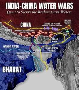
A giant dam can affect the timing and regulation of flows, sediment movement, ecosystems and flood patterns, even if it does not permanently divert the river. The extraordinary seismic vulnerability of the Himalayan region adds another layer of concern. And the greatest problem remains Beijing’s lack of transparency.
India has therefore been pressing China for hydrological data and consultations on transboundary river projects. In August 2026, New Delhi again sought the resumption of vital water-flow data sharing and an early meeting under the two countries’ Expert Level Mechanism.
There is also a strategic irony here. While China calls Arunachal Pradesh “South Tibet”, its growing control over infrastructure and water systems in Tibet gives the territorial dispute a practical dimension beyond maps and mountains. Who controls the high ground controls the headwaters; who controls the headwaters possesses strategic leverage.
This is why India cannot afford to view the Brahmaputra merely as an environmental issue. It is simultaneously a water-security, ecological, economic and national-security issue.
At the same time, New Delhi must avoid exaggeration. The Brahmaputra is not a tap that Beijing can simply turn off. Much of its enormous volume is generated by rainfall and tributaries after the river enters the Himalayan and Indian regions.
The larger lesson, therefore, is clear. The India-China contest is not only about territory; it is increasingly about strategic geography. And water is becoming one of its most valuable assets.
Should geography decide strategy? Absolutely—but India must ensure that its geography becomes an advantage, not a vulnerability.
The answer lies in stronger border infrastructure, better river monitoring, real-time hydrological data, accelerated development of India’s own water and hydropower capabilities and sustained diplomatic pressure for transparency.
The Himalayas may divide India and China politically. But the rivers ignore that boundary.
And in the geopolitics of the future, the country that understands that reality first will possess a formidable strategic advantage.